
The News
We finally get to share some very big news: State of Place has received ~$1.7 million in Phase II funding from the US Department of Transportation’s Small Business Innovation Research program as part of their AI for Transportation Planning and Design (AI TPD) initiative! State of Place’s project - AI for Comprehensive, Efficient, & Safe Streets or ACES - builds upon our 2024 Phase I award and work with SEPTA in Philadelphia. Specifically, ACES will advance our AI-powered approach to collecting and analyzing street-level data and scale our image and sensing hardware. It will also significantly enhance our platform: transportation agencies, planners, and other public- and private-sector “citymakers” can simply specify what mobility objectives they want to achieve - and under what conditions - and the software identifies what to change, where, and why. The result is better places - and a better way to actually get them done.
Show me the data...and...
You can’t improve streets if you don’t know what is happening on them. Transportation agencies still struggle to get timely, scalable, street-level data detailed enough to truly understand conditions block by block. Existing sources can be expensive, infrequently updated, inconsistent across a city, constrained by privacy concerns, or simply too coarse to support the decisions agencies need to make.
But understanding what is happening and where is only half the problem. Knowing a sidewalk is incomplete, a crossing is unsafe, or a transit stop lacks amenities alone does not tell you what changes actually make streets safer and more appealing. ACES tackles both sides: giving agencies a better picture of what's working and what's not - and what to do about it to make safer streets and better places.
But wait, you said Phase TWO?
So yes, we never actually told you about our Phase I SBIR award we received in 2024, which addressed USDOT's need for better street-level data on transportation infrastructure, the context surrounding it, and travel behavior. We partnered with the Southeastern Pennsylvania Transportation Authority (SEPTA) to tackle that challenge across Philadelphia’s bus network. Rather than relying on third-party street-level imagery, we built our own image-capture prototype to give us control over when, where, and how often images were captured. We mounted four smartphones on an RV to emulate the height of a typical city bus, and collected more than 2 million street-level images across 8,000+ blocks across SEPTA’s network.
From those images, we extracted data on 144 built environment features - including sidewalks, crosswalks, street trees, benches, public spaces, and many other urban design characteristics that impact mobility (as well as economic, social, health, and environmental outcomes). We also collected travel behavior data, including pedestrian, bicycle, and vehicle counts and mode share. To do that, we utilized vision-language models (VLMs), which can identify many different features without requiring a separately trained model for each one - making it far faster and easier to expand what we measure.
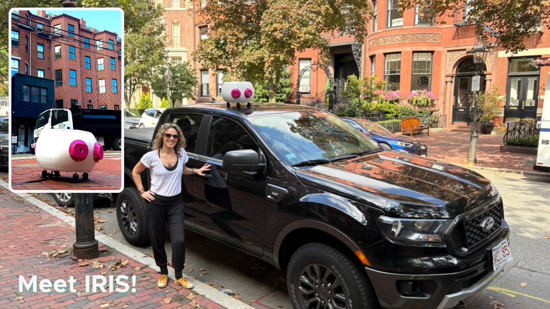
IRIS with our founder, Mariela - for scale!
Enter IRIS!
After Phase I, we had the opportunity to work with CLTRE, a nonprofit community development corporation in Sacramento, on a community engagement project (more on that in another post - stay tuned!). And so enter IRIS: our Intelligent Remote Imaging Sensor. We gradated from our scrappy smartphone prototype to a much more durable, weather-resistant, and scalable Raspberry Pi-based hardware, giving us more control over image capture - and other integrated sensors - storage, and processing. We deployed IRIS in Sacramento's "D2" area and then worked with residents and commercial stakeholders to create a new, evidence-based vision for their district!
And finally...Phase II
Our two-year USDOT Phase II expands and enhances how and what we measure and sharpens our recommendations for what to change, where, and why.
First, IRIS will get a bit of a "bloom" up. We'll be adding several more sensors, including LiDAR and thermal imaging to enable sensor fusion. And don't worry, this isn't about cool tech for tech's sake. Combining all of this sensor-derived data will not just expand the kind of information we can provide cities - we'll actually be able to more accurately detect features that are tricky to extract from imagery alone, including pavement condition, accessibility barriers, and right-of-way obstructions. IRIS will also get a bit more nimble, allowing us to deploy it across a wide range of "vehicles" - from cars to bikes to street sweepers and more - on both State of Place's and government-owned fleets.
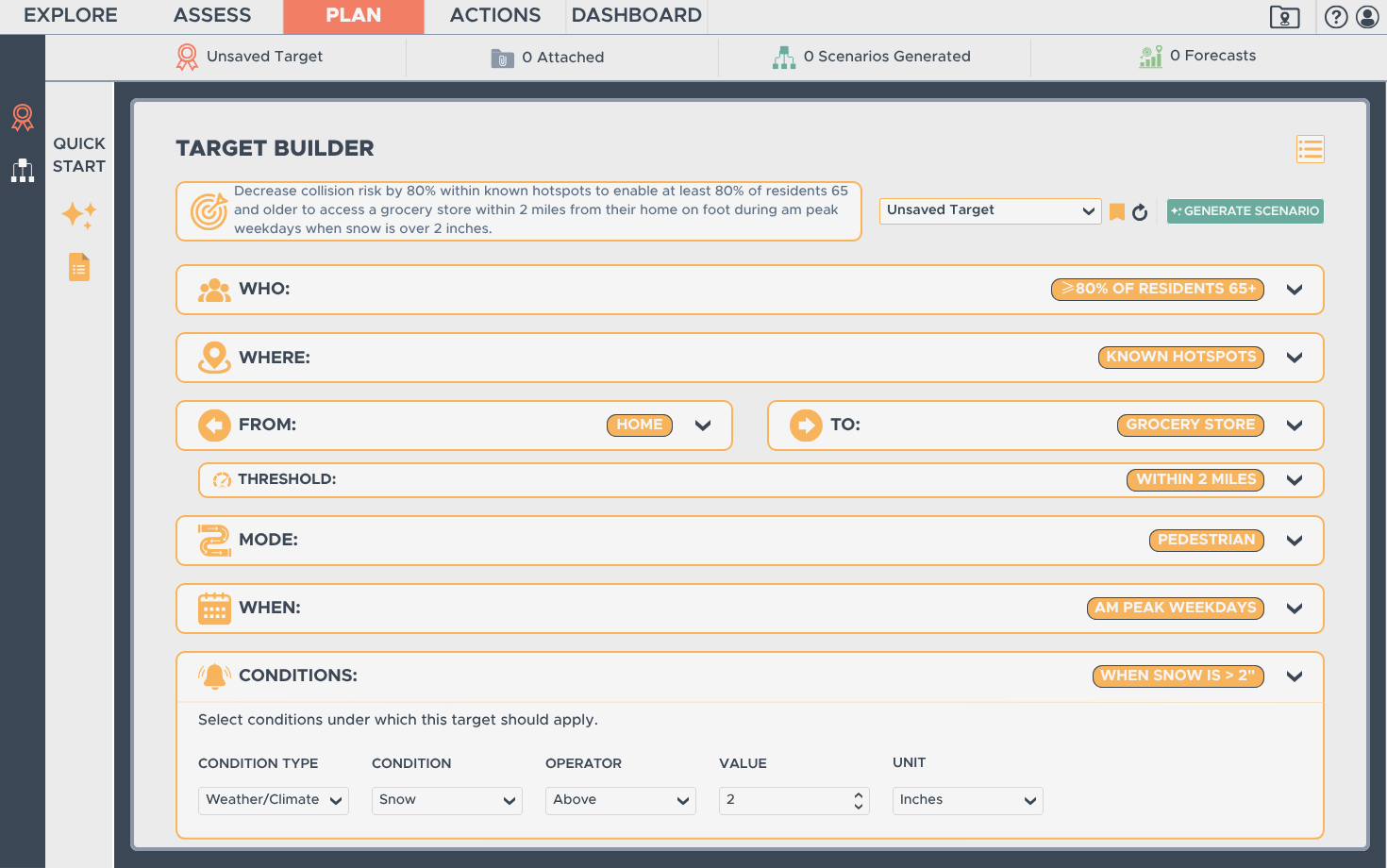
New State of Place Recommendation Engine Prototype
We’re also significantly enhancing our recommendation engine. Today, State of Place identifies and prioritizes the built environment changes most likely to improve a desired outcome. Phase II will make those recommendations both broader and much more precise. First, we’re expanding the forecasting models that provide the evidence behind them - refining our collision, injury, and fatality-risk models, adding near-misses and accessibility, and building on the travel-mode models developed in Phase I.
More importantly, agencies will be able to define exactly what they want to achieve - where, for whom, by how much, and under what conditions - and the software will identify what to change, where, and in what combination to get them there. For example, a user could ask how to increase by 30% the number of residents in a particular area who can walk from home to a grocery store within 15 minutes. While State of Place has always identified which aspects of the built environment matter most to a desired outcome, ACES will let users start with a precise target and work backward to the specific changes and locations most likely to achieve it.
Building It With Agencies
We are building ACES with transportation agencies, not just for them. Phase II expands the work beyond Philadelphia to five pilot geographies: Charlotte, the Syracuse metropolitan area, San Diego, the Kansas City region, and Colorado Springs. Before Phase II even began, we held workshops with several of these partners to understand the problems they were trying to solve, the data they were missing, and what would actually make the solution useful in practice.
Those conversations have already shaped the project. Agency partners identified needs such as better data on pavement condition, accessibility barriers, and right-of-way obstructions, which are now part of what we will develop and test through Phase II. That co-creation will continue throughout the project as agencies help shape what data we collect, how we collect it, and how they use it within our decision-support tools to ensure that what we build actually helps them build better places.
“The ultimate goal is not better data, or even better technology. It is better streets and better places.”
Why It Matters
The ultimate goal is not better data, or even better technology. It is better streets and better places. Transportation agencies face limited resources, competing priorities, difficult political realities, and a long list of things that could be improved. The hard part is determining what matters most, what to do about it, where to do it, and whether the expected benefit is worth the investment. And even then, somebody still has to approve it, fund it, and build it.
State of Place is designed to connect those pieces: understand existing conditions, identify and prioritize the built environment changes most likely to improve the outcomes people care about, quantify their expected value, and provide the evidence-based guidance and proof needed to get those changes done. While ACES is being developed with USDOT and transportation agencies, its value extends far beyond transportation. Virtually anyone making decisions about where and how to invest in the built environment can benefit from ACES.
What’s Next
Phase II officially begins now, and we have a lot to build! Over the next two years, we’ll be working alongside our five pilot partners to develop, test, and refine ACES in very different places, against very different transportation challenges. We’ll be sharing that work along the way, and this time we promise not to wait until Phase III to tell you what happened!
If you want to learn more or help shape what we’re building, please get in touch! We’d love to hear from both public- and private-sector citymakers who want to learn more about ACES or State of Place more generally, or simply want to be part of the broader community helping to deliver better places.